RAMI2 phase
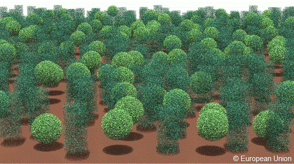
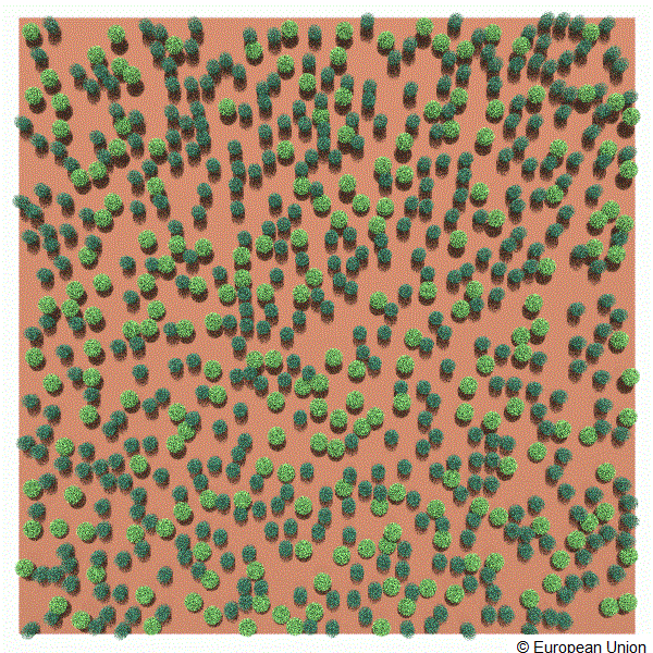
This set of experiments was suggested to simulate the radiative transfer regime at different spatial resolutions in the near infra-red spectral band for spatially heterogeneous scenes composed of a large number of disc-shaped scatterers contained within a series of non-overlapping spherical and cylindrical volumes. The latter entities - representing individual plant crowns - were located over and covered only some of the horizontal plane standing for the underlying soil surface.
The finite sized scatterers of disc-like shape, that are randomly distributed within the spherical and cylindrical volumes, were characterized by their specific radiative properties (reflectance, transmittance), and the orientation of their scatterer-normals (uniform distribution). The radiative properties of the underlying soil were also specified (in this case a simple Lambertian scattering law). The particular values selected for these input variables represented classical plant canopy conditions.
The following figures exhibit a graphical representation of this scene:
looking from across northern edge in a southward direction towards the centre of the scene:
looking vertically down towards the center of the scene:
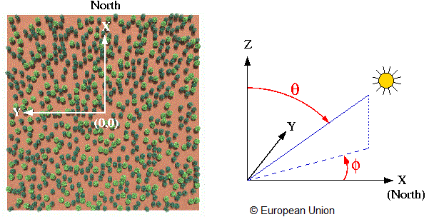
The zero azimuth line was defined along the northern direction and coincides with the positive X axis as indicated below:
The architecture of this scene is precisely characterized as follows:
| Scene dimensions: (ΔX × ΔY × ΔZ) | 270.0 × 270.0 × 15.0 [m × m × m] |
| (Xmin, Ymin, Zmin) | −135.0, −135.0, 0.0 [m, m, m] |
| (Xmin, Ymax, Zmin) | −135.0, +135.0, 0.0 [m, m, m] |
| (Xmax, Ymin, Zmin) | +135.0, −135.0, 0.0 [m, m, m] |
| (Xmax, Ymax, Zmin) | +135.0, +135.0, 0.0 [m, m, m] |
| (Xmin, Ymin, Zmax) | −135.0, −135.0, 15.0 [m, m, m] |
| (Xmin, Ymax, Zmax) | −135.0, +135.0, 15.0 [m, m, m] |
| (Xmax, Ymin, Zmax) | +135.0, −135.0, 15.0 [m, m, m] |
| (Xmax, Ymax, Zmax) | +135.0, +135.0, 15.0 [m, m, m] |
| Scatterer shape | Disc of negligible thickness |
| Scatterer radius | 0.05 [m] |
| LAI of individual sphere | 5.0 |
| LAI of individual cylinder | 5.0 |
| Scatterer normal distribution | Uniform |
| Number of spheres | 205 |
| Number of cylinders | 409 |
| Number of spheres + cylinders | 614 |
| Fractional scene area coverage of spheres | 0.1414 |
| Fractional scene area coverage of cylinders | 0.1586 |
| Combined fractional scene area coverage | 0.3000 |
| Sphere radius | 4.0 [m] |
| Cylinder radius | 3.0 [m] |
| Cylinder height | 12.0 [m] |
| Top-of-canopy height | 15.0 [m] |
where the Leaf Area Index (LAI) was calculated as follows:
LAI = (# of leaves × one-sided area of single leaf) ⁄ (π × square of the radius of sphere or cylinder)
A list of the 205 (X, Y, Z) coordinates of the sphere centers can be found here, and the 409 (X, Y, Z) center coordinates of the lower cylinder-side can be found here.
The underlying soil is occupying the entire lower surface of the scene, i.e., the area enclosed between the following coordinates: (−135.0, −135.0, 0.0), (−135.0, +135.0, 0.0), (+135.0, −135.0, 0.0), and (+135.0, +135.0, 0.0), where all values are given in meters.
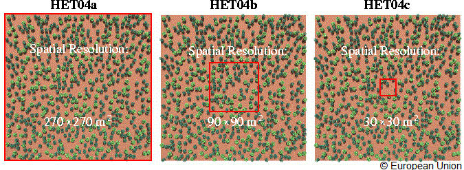
HET04* indicates the fact that the heterogeneous discrete scene described above will have to be analysed at three different spatial resolutions, that is, the set of RAMI measurements will have to be performed over successively smaller target areas located at the centre of this scene. Three different types of target areas are envisaged, ie., HET04a ⇒ 270 by 270 m²; HET04b ⇒ 90 by 90 m² and HET04c ⇒ 30 by 30 m². It is important that for all three HET04* experiments the entire 270×270 m² scene architecture is taken into consideration (ie., illuminated) even though the RAMI measurements are only carried out over the respective target areas.
The fraction of absorbed radiation (by the disc-scatterer) has to be computed using only the incident radiation that passes through the above target areas located at the top of the canopy (Zmax). Similarly the transmission through the medium at the lower boundary level (direct + diffuse radiation reaching the soil level) has to be computed with respect to the incident flux at the corresponding target area located at the top of the canopy (Zmax).
The BRF definition of Nicodemus (1977) requires it to be measured with respect to a planar surface located at some reference height. Thus for each of the HET04* experimental setups the BRF measurements have to be carried out using only the incident and exiting radiation passing through a reference plane of equal dimensions than the square shaped target area of interest, that is located at a height equal to the top of the canopy (Zmax). True Zoom-ins have to be performed, that is, the entire canopy architecture of the 270×270 scene has to be taken into account for all HET04* experiments even though the actual measurements are only performed over the corresponding areas of interest - with the following specific details:
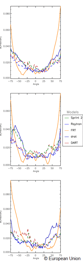
The following Figure shows the detailed contributions of the individual models to a series of histograms of local angular model deviation values estimated for viewing conditions in the principal plane and cross planes, in the near-infrared wavelengths, for the ensemble of the "Real Zoom-in" heterogeneous test cases.

The next figure shows the angular deviation of the model simulations for the total BRF (one versus all others) as a function of view angle, for all of the required "Real Zoom-in" testcases: