This set of experiments, which was first suggested during the second phase of RAMI, has been expanded in scope to cover multiple reference area (i.e., pixel or IFOV) locations, and a new type of measurement that has never featured in any of the previous phases of RAMI. In essence,
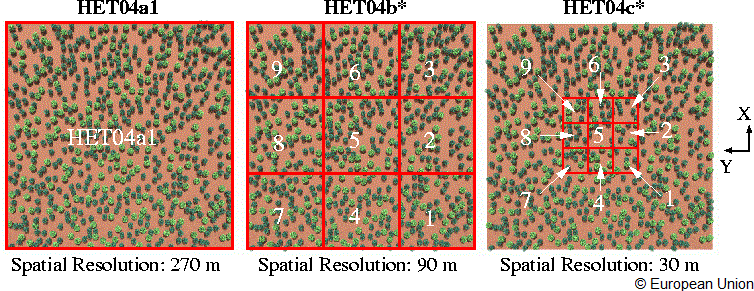
radiation transfer simulations at the top of the canopy are to be carried out in the near-infrared wavelength at different spatial resolutions (270, 90 and 30 m) and for precisely located square-shaped reference areas (pixels) within the overall scene (270×270 m²).
normalized horizontal flux measurements are to be carried out for the 4 lateral sides of (box-shaped) voxels containing the vegetation canopy at precisely determined locations within the overall scene, and this at different spatial resolutions (270, 90 and 30 m).
Both types of measurements apply to the same (square-shaped reference area) locations within the overal scene and will be described in more detail later on. At this stage, further information on the structural and spectral properties of the scene - which remain the same as during the second phase of RAMI - will be provided first.
The scene is composed of a large number of disc-shaped scatterers that are contained within a series of non-overlapping spherical and cylindrical volumes. The latter entities - representing individual plant crowns - do not vary in size, and are positioned at precisely determined locations above (and covered only some of) the horizontal plane standing for the underlying soil surface.
The disc-shaped scatterers are randomly distributed within the spherical and cylindrical volumes and characterized by their specific radiative properties (reflectance, transmittance), as well as the orientation of their scatterer-normals (uniform distribution).
The radiative properties of the underlying soil were also specified (in this case a simple Lambertian scattering law). The particular values selected for these input variables represented classical plant canopy conditions.
To address the needs of different RT models, we are providing files with the exact spatial coordinates of every leaf location within one spherical and one cylindrical volume You may or may not make use of this information depending on the needs of your particular model. On the other hand, participants that wish to perform the real zoom in simulations must make use of the information in the two ASCII files containing the exact sphere and cylinder center locations.
It is important that for each of the HET04** experiments the entire 270×270 m² scene architecture is taken into consideration (ie., illuminated) even though the various RAMI measurements are only carried out over part of the area of the scene, or more precisely, by accounting only for that radiation that enters and exits the scene via the specified reference areas: HET04a1, HET04b* and HET04c*.
Note that in each of the above scenarios cyclic boundary conditions still apply, i.e., all radiation that leaves the overall (270×270 m²) scene area laterally is compensated by an equivalent amount of radiation that enters the scene (with the same direction) via the opposite lateral side. These radiation contribute to the various HET04** measurements.
Since the reference level for all HET04** experiments is located at Zmax=15m, participants can verify their simulations by 1) averageing all HET04c* measuring and comparing them to the values of the HET04b5 experiment, and 2) averageing all HET04b* measuring and comparing them to the value of the HET04a1 experiment. In both cases the average of the higher spatial resolution simulations should equal the value obtained at the coarser spatial resolution.
Structural properties
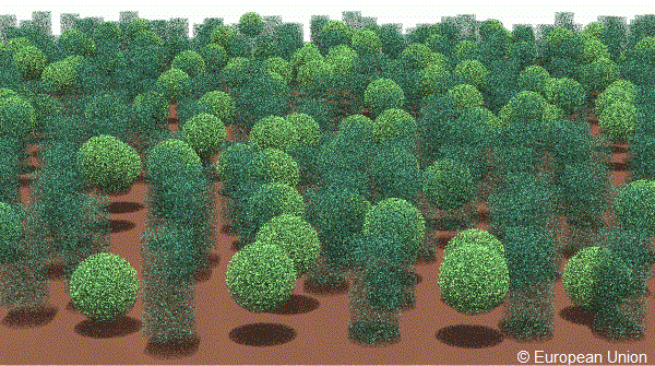
The following figures exhibit a graphical representation of this scene looking from across northern edge in a southward direction towards the centre of the scene.
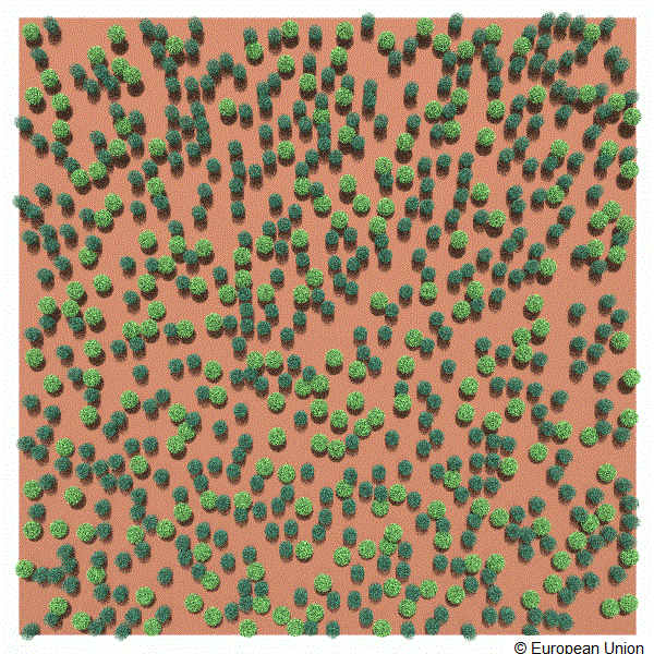
The following figures exhibit a graphical representation of this scene looking vertically down towards the center of the scene.
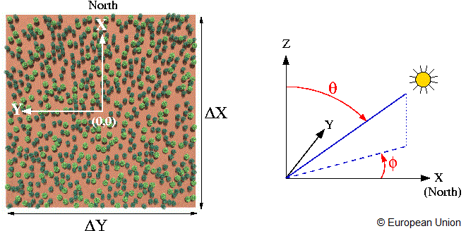
The zero azimuth line was defined along the northern direction and coincides with the positive X axis as indicated below:
The zero azimuth line.
Architecture scene
The architecture of this scene is precisely characterized as follows:
Scene dimensions: ( ΔX × ΔY × ΔZ)
270.0 × 270.0 × 15.0 [m × m × m]
(Xmin, Ymin, Zmin)
−135.0, −135.0, 0.0 [m, m, m]
(Xmin, Ymax, Zmin)
−135.0, +135.0, 0.0 [m, m, m]
(Xmax, Ymin, Zmin)
+135.0, −135.0, 0.0 [m, m, m]
(Xmax, Ymax, Zmin)
+135.0, +135.0, 0.0 [m, m, m]
(Xmin, Ymin, Zmax)
−135.0, −135.0, 15.0 [m, m, m]
(Xmin, Ymax, Zmax)
−135.0, +135.0, 15.0 [m, m, m]
(Xmax, Ymin, Zmax)
+135.0, −135.0, 15.0 [m, m, m]
(Xmax, Ymax, Zmax)
+135.0, +135.0, 15.0 [m, m, m]
Scatterer shape
Disc of negligible thickness
Scatterer radius
0.05 [m]
LAI of individual sphere
5.0 [-]
LAI of individual cylinder
5.0 [-]
Scatterer normal distribution
Uniform
Number of spheres
205 [/scene]
Number of cylinders
409 [/scene]
Number of spheres + cylinders
614 [/scene]
Fractional scene area coverage of spheres
0.1414
Fractional scene area coverage of cylinders
0.1586
Combined fractional scene area coverage
0.3000
Sphere radius
4.0 [m]
Cylinder radius
3.0 [m]
Cylinder height
12.0 [m]
Top-of-canopy height
15.0 [m]
where the Leaf Area Index (LAI) was calculated as follows:
LAI = (number of leaves × one-sided area of single leaf) ⁄ (π × square of the radius of sphere or cylinder)
Two optional ASCII files with the radius (R), centre coordinates (Xc,Yc,Zc), and direction cosines (Dx,Dy,Dz) of every single leaf in a spherical and cylindrical volume centered at 0,0,0 are provided. This files (are ~ 1.4 and 0.8 Mbytes, respectively, and) contain 31999 and 17999 lines each of format R Xc Yc Zc Dx Dy Dz and may serve as input to your scene creation process (provided that you are able to create multiple instances of their content, that are then translated to the actual locations of the sphere and cylinder centers in the scene specified below.
A list of the 205 (X, Y, Z) coordinates of the sphere centers can be found here, and the 409 (X, Y, Z) center coordinates of the lower cylinder-side can be found here. These files must be used by all those participants wishing to perform the real zoom-in measurements.
The underlying soil is occupying the entire lower surface of the scene, i.e., the area enclosed between the following coordinates: (−135.0, −135.0, 0.0), (−135.0, +135.0, 0.0), (+135.0, −135.0, 0.0), and (+135.0, +135.0, 0.0), where all values are given in meters.
The figures displays reference locations for local measurements.
Setup for measurements 2-10
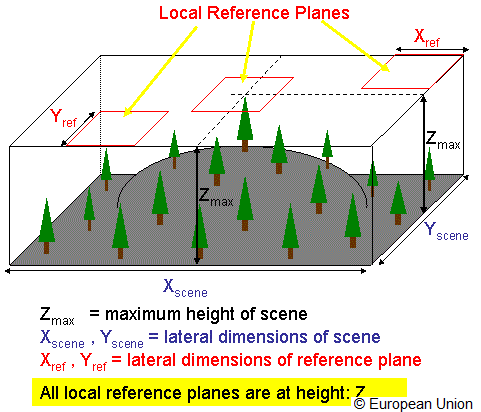
The BRF definition of Nicodemus (1977) requires it to be measured with respect to a planar surface located at some reference height. Thus for each of the HET04** experimental setups the BRF measurements have to be carried out using only the incident and exiting radiation that passes through a reference plane of dimensions equal to the square shaped reference area described above. Note, that this reference plane must be located at a height equal to the top of the canopy (Zmax). Again, true zoom-ins have to be performed, that is, the entire canopy architecture of the 270×270 scene has to be illuminated for each of the HET04** experiments even though the actual measurements are only performed over the smaller areas of interest.
The figures displays reference plane of dimensions equal to the square shaped reference area.
Setup for measurements 1 and 11
The fraction of absorbed radiation (by the disc-scatterer) has to be computed using only the incident radiation that passes through the above square-shaped reference areas located at the top of the canopy (Zmax). Similarly the transmission through the medium at the lower boundary level (direct + diffuse radiation reaching the soil level) has to be computed with respect to the incident flux at the corresponding square-shaped reference area located at the top of the canopy (Zmax).
Setup for measurement 12
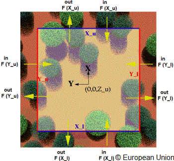
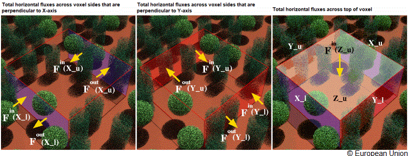
The normalized horizontal fluxes have to be computed for a series of voxels whose upper (Zu) surface coincides - both in terms of dimensions and location - with the 19 local reference areas defined above. Obviously the area of the Zu surface will differ from that of the lateral ones. Click here for a visualization of the geometry and relevant flux quantities pertaining to the voxel located at the HET04c5 reference area. For further informationon the normalized horizontal flux measurement click on the appropriate link in the measurement list at the end of this page.
Topview of reference area HET04c5
Sideview of voxel at HET04c5
Reference
Nicodemus, F. E., Richmond, J. C., Hsia, J. J., Ginsberg, I. W. and Limperis, T., (1977)
Geometrical Considerations and Nomenclature for Reflectance, National Bureau of Standards, U.S. Department of Commerce, NBS Monograph,160,Washington, DC.